We're entering what researchers call an "imminent data desert." Critical stratospheric measurements—water vapor, halogen species like chlorine, and transport tracers such as methane—will vanish from global coverage just as the stratosphere experiences unprecedented perturbations. The 2019-2020 Australian wildfires, the 2022 Hunga Tonga volcanic eruption, and accelerating climate shifts have thrust the stratosphere into one of the most unusual periods on record. Losing the ability to monitor it now would be catastrophic.
This article examines what data is at risk, why current collection platforms are struggling, what consequences follow, and what emerging approaches—including rapid payload delivery systems—offer a path forward.
Key Takeaways
- NASA's Aura (MLS) and Canada's SCISAT-1 (ACE-FTS) satellites face decommissioning by mid-2026, creating critical stratospheric monitoring gaps with no replacement missions currently scheduled
- Critical variables—stratospheric water vapor, chlorine species (HCl, ClO), and tracers (N2O, CH4)—will lose daily global coverage
- Ground-based and suborbital platforms cannot replicate the global spatial and temporal coverage that satellites provide
- Data gap coincides with the most perturbed stratospheric period on record, including impacts from Hunga Tonga and Australian wildfires
- Hydrogen-oxygen light-gas launch systems offer rapid, low-cost deployment of small instruments directly into stratospheric altitudes
Why Real-Time Stratospheric Data Is Irreplaceable
The stratosphere does more than host the ozone layer. It regulates surface climate through water vapor feedbacks and acts as the primary transport medium for pollutants and volcanic aerosols circling the globe.
Understanding this atmospheric region requires more than column averages. Scientists need vertical profile data showing how chemical composition changes at specific altitude layers and latitudes.
This vertical resolution is essential. Ozone depletion occurs through complex chemistry involving chlorine, nitrogen, and hydrogen species. Without altitude-specific measurements, separating dynamical transport effects from actual chemical loss becomes statistically impossible. Researchers must know not just that ozone decreased, but where, when, and through what mechanism.
Instruments That Currently Anchor Our Understanding
Two cornerstone instruments provide the backbone of today's stratospheric monitoring:
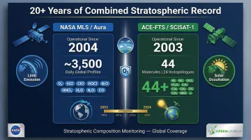
NASA's Microwave Limb Sounder (MLS) on the Aura satellite has delivered daily near-global limb emission measurements since 2004. MLS measures 9+ key species including ozone (O3), hydrogen chloride (HCl), chlorine monoxide (ClO), hypochlorous acid (HOCl), bromine monoxide (BrO), nitric acid (HNO3), water vapor (H2O), nitrous oxide (N2O), and carbon monoxide (CO).
Canada's Atmospheric Chemistry Experiment Fourier Transform Spectrometer (ACE-FTS) on SCISAT-1 has provided solar occultation profiles since 2003. ACE-FTS measures 44 molecules and 24 isotopologues — the most comprehensive chemical inventory of the stratosphere currently available from a single instrument.
These instruments track four irreplaceable phenomena:
- Ozone depletion from anthropogenic halogens
- Stratospheric response to extreme events like volcanic eruptions and wildfires
- Stratospheric water vapor changes and their climate feedbacks
- Strength of the Brewer-Dobson circulation pattern
Why Continuity of Record Matters
Trend detection in atmospheric science demands multi-decade, consistent data records. Even small calibration inconsistencies between instruments from different eras introduce uncertainty that can obscure real trends. Losing MLS and ACE-FTS breaks continuity of records built over 20+ years, not merely pausing them.
Consider the stratospheric ozone recovery story. Scientists can confirm that the Montreal Protocol — the global agreement phasing out ozone-depleting substances — is working because of exactly this type of long-term, vertically resolved monitoring. Without that record, no statistical framework exists to separate genuine chemical recovery from natural variability.
The Gaps Widening in Today's Monitoring Networks
The "data desert" concept isn't hyperbole. Aura's decommissioning is expected no later than mid-2026. SCISAT-1 is operating 20.6 years beyond its 2-year design lifetime—an extraordinary run, but one approaching its end. The window for an orderly transition to replacement systems is closing.
What Will Actually Go Dark
Specific measurement types will be lost when these satellites cease operations:
- Daily near-global profiles of stratospheric water vapor (H2O)
- Inorganic chlorine species (HCl, ClONO2, ClO)
- Nitrogen species (HNO3)
- Long-lived transport tracers (N2O, CH4)
No other confirmed future mission measures these species at this spatial and temporal density.
Polar coverage will collapse. MLS provides dense coverage over Arctic and Antarctic regions—critical for monitoring polar vortex chemistry and the annual ozone hole. After decommissioning, polar stratospheric coverage drops to sparse, seasonally limited observations exactly when scientists need continuous monitoring most.
What Remains: Partial Coverage Only
Several instruments will continue operating post-decommissioning, but they don't replace what's being lost:
| Instrument | Platform / Agency | Status |
|---|---|---|
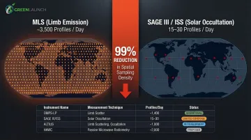
| OMPS-LP | Suomi NPP, NOAA-20, NOAA-21 | Operating — ozone and aerosol limb scattering |
| SAGE III/ISS | International Space Station | Operating — solar occultation profiles, extended to 2026+ |
| ALTIUS | ESA | Planned launch 2028 |
| HAWC | Canadian Space Agency | In development, planned launch 2031 |
None of these platforms replace the daily near-global halogen and tracer coverage lost with MLS and ACE-FTS. The numbers make the gap concrete: limb emission instruments like MLS provide approximately 3,500 daily near-global profiles, while solar occultation instruments like SAGE III/ISS deliver only 15 to 30 per day — a 99% reduction in spatial sampling density.
The Ground-Based Safety Net and Its Limits
Ground-based systems supplement satellite data but cannot replace it:
- Balloon-borne ozonesondes and frostpoint hygrometers
- Ozone and aerosol lidars
- NDACC (Network for the Detection of Atmospheric Composition Change) ground stations with FTIR spectrometers and microwave radiometers
These provide valuable long-term records but are geographically sparse. Without satellite context, ground-based measurements are harder to interpret — trend analysis depends on high-density spatial sampling that no surface network can deliver on its own.
Why Current Collection Methods Are Falling Short
Stratospheric data collection depends on a small number of large, expensive satellites that take a decade or more to design, fund, build, and launch. That development cycle cannot respond to unexpected coverage gaps — and the gaps are already here.
The Satellite Development Timeline Problem
The gap between identifying a data need and fielding a replacement satellite spans 10-15 years for typical large-satellite development. NASA's Aura mission illustrates this timeline: selected in 1990, it launched in 2004—a 14-year development cycle from concept to orbit.
Aura's successor instruments have no confirmed launch dates. Any replacement will arrive years into the data desert rather than at its onset. The same pattern repeats across Earth observation programs, making this a structural vulnerability rather than an isolated delay.
Sampling Geometry Constraints of Existing Alternatives
Solar occultation instruments cannot fill the MLS gap due to fundamental physics. They measure only when the Sun geometrically aligns with their line of sight, yielding ~30 profiles per day globally versus hundreds from limb emission instruments. This sparse sampling is inadequate for:
- Tracking rapidly evolving polar chemistry
- Diagnosing sudden injection events from volcanoes or wildfires
- Capturing diurnal variations in short-lived species
Polar regions suffer most. Occultation instruments measure at only certain latitudes and local times depending on orbital geometry. Polar night periods—when the ozone hole develops—receive no spaceborne profile data.
The Compounding Effect of Concurrent Technology Aging
The data gap problem extends beyond stratospheric chemistry. Two additional long-running instruments have gone dark in recent years:
- CALIOP (Cloud-Aerosol Lidar with Orthogonal Polarization) — ended its 17-year science mission on August 1, 2023
- MOPITT (Measurements of Pollution in the Troposphere) — powered off April 9, 2025, after 25 years observing carbon monoxide
With each loss, researchers have fewer independent data streams to cross-validate models and detect emerging atmospheric events — compounding the risk that critical changes go undetected until the record can be reconstructed retrospectively.
The Compounding Risks of Incomplete Stratospheric Data
Losing real-time stratospheric profile data isn't merely inconvenient for researchers. It has direct consequences for ozone layer monitoring, climate prediction, and the ability to respond to extreme events.
Ozone Recovery and Regulatory Science Will Stall
The Montreal Protocol's success story depends on measuring the actual stratospheric chlorine and ozone signal, not just modelling it. Without HCl, ClO, and N2O profiles, attributing observed ozone changes to chemistry versus dynamics becomes statistically unreliable.
Consider the 2019-2020 Australian wildfires. MLS and ACE-FTS observations revealed unprecedented 50-60% depletion in stratospheric HCl, accompanied by enhancements in ClO and ClONO2. This indicated heterogeneous chlorine activation on widespread smoke particles—a mechanism that models didn't predict and that wouldn't have been diagnosed without high-resolution chemical profiling.
Extreme Events Will Go Uncharacterized
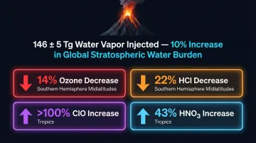
The data desert coincides with unprecedented stratospheric perturbation. The 2022 Hunga Tonga eruption injected 146 ± 5 Tg of water vapor into the stratosphere—a 10% increase in global stratospheric water burden. MLS tracked this injection for years, revealing its effects on global chemistry:
- 14% ozone decrease in Southern Hemisphere midlatitudes
- 22% hydrogen chloride decrease in Southern Hemisphere midlatitudes
100% chlorine monoxide increase in the tropics
- 43% nitric acid increase in the tropics
Without equivalent instruments, future events will remain diagnostic black holes. That gap doesn't just limit scientific understanding—it removes the observational foundation needed to assess the next major stratospheric disruption, whether natural or deliberate.
Geoengineering Monitoring Will Be Blind
The U.S. National Academies' 2021 Reflecting Sunlight report draws a direct line between Stratospheric Aerosol Injection (SAI) governance and observational infrastructure: continuation of limb emission and infrared solar occultation observations is explicitly required for tracking global vertical profiles of ozone and climate-related trace gases.
If SAI were ever deployed—intentionally or accidentally—the only way to assess its chemical and dynamical effects on the ozone layer would be through the exact instruments now facing decommissioning. Decommissioning those instruments while SAI deployment scenarios move from theory to policy removes the only means of detecting whether an intervention is working—or causing harm.
Emerging Approaches to Closing Real-Time Data Gaps
Several strategies are being developed to address the monitoring gap, from new satellite missions to faster, cheaper instrument deployment platforms.
Next-Generation Satellite Planning and International Coordination
The scientific community is calling for a new generation of limb emission or occultation instruments designed for daily near-global profile measurements. Scientists urgently need to develop formal requirements—targeting continuous trend monitoring, extreme event response, and geoengineering oversight capability—before the gap deepens.
Currently, no confirmed plans exist to obtain daily near-global coverage of halogenated species (ClO, ClONO2, HCl), tracers of stratospheric transport (N2O, CH4), or anthropogenic pollution (HCN, CO, CH3Cl) once MLS and ACE-FTS are decommissioned.
The 2022 WMO/UNEP Scientific Assessment of Ozone Depletion warns that without replacements, the ability to monitor and explain changes in the stratospheric ozone layer in the future will be impeded.
Expanding Suborbital and On-Demand Measurement Capability
No single suborbital system replaces a satellite. But an expanded, coordinated network of high-altitude balloon campaigns, aircraft-based instruments, and sounding rockets can provide targeted measurements during critical events or data-sparse periods.
The key constraint isn't technology—it's access frequency and cost. Systems that can launch scientific payloads into the stratosphere on short notice expand the cadence and geographic distribution of suborbital measurements in ways balloon campaigns alone cannot match.
**Green Launch's hydrogen-oxygen powered light-gas technology** offers exactly this kind of on-demand access. The system delivers payloads to high altitudes cost-effectively, giving scientists direct access to the stratosphere when and where satellite data goes dark.
Key system characteristics include:
- Accelerates payloads through a launch tube to velocities exceeding Mach 9
- Produces only water vapor as exhaust, with minimal environmental footprint
- Supports 60-90 minute turnaround times between successive missions
- Demonstrated 200 km altitude delivery for sensor packages and atmospheric samplers
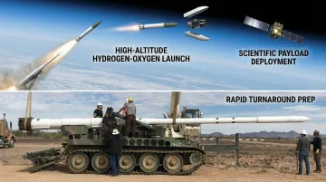
For atmospheric sampling campaigns, that turnaround matters. Following unexpected events like volcanic eruptions, scientists could run multiple sampling missions within days rather than waiting months for traditional sounding rocket manifests. Green Launch has demonstrated a one-month turnaround on full sounding experiments.
The company's pricing structure of **$100 per pound** for payload delivery offers significant cost advantages over traditional rockets—enabling the frequent, targeted measurements that satellite gaps demand.
Commercial and Small Satellite Constellations
Commercial CubeSat and small satellite technology is increasingly capable of hosting atmospheric profiling instruments at lower cost and shorter development timelines than traditional large missions.
A constellation of small limb-sounder satellites could approach the spatial coverage of a single MLS-class instrument at a fraction of the cost and with shorter deployment timelines. While technical challenges remain—particularly power and antenna size for microwave instruments—rapid advances in miniaturization make this approach increasingly viable.
Frequently Asked Questions
What is a stratospheric "data desert" and why is it a concern now?
This term refers to the anticipated loss of daily near-global stratospheric profile measurements when Aura (MLS) and SCISAT-1 (ACE-FTS) are decommissioned by mid-2026. No confirmed replacement missions exist to fill their coverage, leaving critical chemical species unmeasured during a period of unprecedented atmospheric perturbation.
Which atmospheric variables are most at risk of losing real-time coverage?
Several species have no confirmed future measurement continuity: stratospheric water vapor (H2O), inorganic chlorine species (HCl, ClO, ClONO2), nitrogen-family tracers (N2O, HNO3), and pollution tracers (CO, HCN). All are essential for diagnosing ozone chemistry and validating Montreal Protocol effectiveness.
Can ground-based instruments compensate for the loss of satellite stratospheric monitoring?
Ground-based platforms like balloon sondes, lidars, and FTIR spectrometers provide valuable data but are geographically limited. They cannot replicate the daily near-global vertical profile coverage that limb emission satellites provide, making trend analysis unreliable and extreme event diagnosis reactive rather than predictive.
How did the 2022 Hunga Tonga eruption illustrate the importance of real-time stratospheric data?
MLS detected the eruption's stratospheric water vapor injection within days, tracked it globally for years, and quantified an unprecedented 10% increase in global stratospheric water burden — along with the resulting ozone chemistry impacts. Without dense real-time profile measurements, those chemical consequences would have gone uncharacterized until far too late for a timely scientific or policy response.
What role could rapid-deployment launch systems play in closing stratospheric data gaps?
On-demand, high-altitude launch systems can deploy stratospheric instruments quickly and affordably for targeted campaigns, supplementing satellite coverage during gap periods or after sudden atmospheric events. With turnaround times as short as 60-90 minutes, multiple sampling missions per day become feasible where satellite data is absent.
How does the loss of stratospheric monitoring data affect climate science and ozone policy?
Attributing ozone changes to specific chemical or dynamical causes requires continuous, vertically resolved measurements of halogen and tracer species. Without that continuity, Montreal Protocol assessments lose statistical reliability and ozone recovery projections become too uncertain to support credible policy decisions.